

I landed in Madeira on a humid April afternoon, flying in from Lisbon with six full days to “see the island.” I had booked an apartment above Funchal’s old town, reserved a small rental car, and arrived with a vague picture of Madeira as a kind of Portuguese Hawaii: palm trees, easy coastal drives, and the odd gentle levada walk between long seafood lunches. By the end of the week, after sweating up near-vertical streets, inching through cloud on mountain roads and chasing patches of blue sky across three weather zones in a single morning, I understood that Madeira is less a beach holiday destination and more a compact, very steep, very beautiful mountain world where the sea just happens to be wrapped around the edges.
Arriving in Madeira and Realising Funchal Is Not the Whole Island
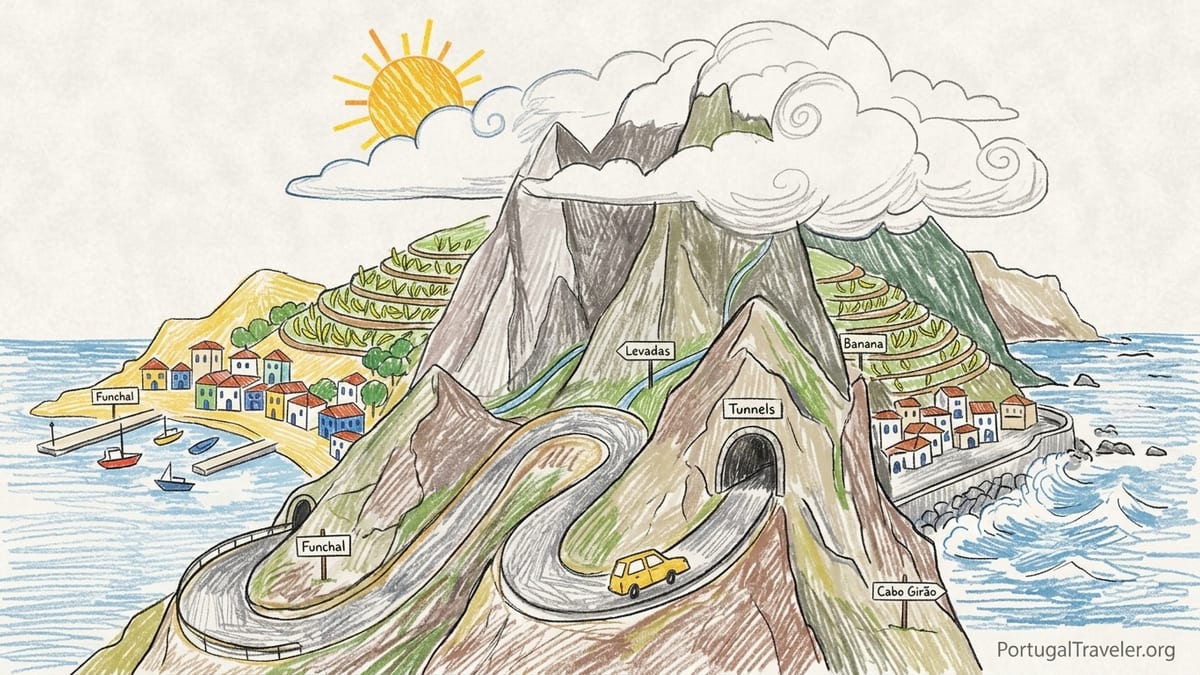
The first shock came before I even left the airport. As the plane dipped toward Cristiano Ronaldo Airport, I could see how abruptly the island rises from the Atlantic. Terraced banana plantations climbed from the shoreline, and then within minutes the hills folded into sharp ridges disappearing into cloud. This was not the gentle, rolling island I had imagined from glossy brochures. It looked more like someone had lifted a piece of the Alps and dropped it in the ocean.
I picked up a compact rental car from one of the desks inside the arrivals hall and immediately faced another reality: to go almost anywhere on Madeira, you drive into a tunnel or up a slope that feels close to a ski road. The fast ER101 and VR1 roads are built through a chain of tunnels that often run for a kilometre or more at a time. The first evening, the combination of dim tunnel lighting, wet road surfaces and unfamiliar signage made the ten-minute drive to my Funchal apartment feel much longer than the distance on the map.
That apartment was in the upper part of Funchal, well above the seafront. On a street map it looked walkable, but the reality was a staircase of residential lanes that seemed to be pitched at 20 to 30 degrees. Walking down into the old town for dinner meant fifteen minutes of careful steps on polished cobbles. Walking back up after grilled limpets and espetada skewers meant a sweaty twenty-minute climb that felt like mild interval training. It was my first planning mistake: in Funchal a hotel’s altitude matters almost as much as its distance from the centre.
Funchal itself, however, fit my expectations. Down at sea level the climate felt almost subtropical, with evenings in the high teens Celsius even in spring. Pavement cafes along Avenida do Mar were busy, cruise passengers wandered between the Mercado dos Lavradores and the cable car station, and the harbour was sheltered enough that the sea looked more like a lake. It would have been easy to spend the entire week in this comfortable bubble and say I had “done Madeira.” The problem is that Madeira beyond Funchal is another island altogether.
Driving an Island of Tunnels, Ridges and Time Warps
I had imagined that staying in Funchal and “day-tripping” would be efficient. Madeira looks small on the map, just 57 kilometres long. On my second day I drove the short distance west to Câmara de Lobos and then on to Cabo Girão, one of the highest sea cliffs in Europe. The VR1 motorway delivered me there quickly through a series of tunnels, and I began to think the island was indeed compact and easy to cross. Then I turned off toward the interior.
The roads that climb from the south coast up to the central mountains are steep, narrow and twisting. Hairpin bends are common, and many sections have no shoulder at all. Even with modern engineering, the terrain wins. Climbing from Ribeira Brava toward the plateau of Paul da Serra, I found myself in second gear much of the time. What looked like a 25 kilometre hop on the map consumed close to an hour, and that was without stopping at miradouros. Every village along the way added speed bumps, tight turns and the occasional sudden stop for a local van reversing out of a courtyard.
Time also behaves strangely once you leave the main dual carriageways. One morning I set out from Funchal with the idea of seeing the viewpoint at Eira do Serrado, dropping into Curral das Freiras, and then driving across to the north coast around São Vicente before looping back via the Encumeada pass. On paper it was an elegant circle. In practice, by the time I had navigated the switchbacks down into the Nuns Valley, found a legal place to park on the narrow streets, and then climbed back out on the one-road-in-one-road-out route, half the day had gone. I reached São Vicente mid-afternoon, under thick cloud and drizzle, and still had a long drive through tunnels and overpasses to get home. My planned “circle of highlights” was really a long day of chasing road lines through valleys.
Another quirk is how much the tunnels change your sense of place. You can drive from sun into thick grey cloud and back again in the space of ten minutes without seeing the transition. Leaving the south coast toward the centre, I would often enter a tunnel in bright light, and then emerge onto a high road in swirling fog with visibility cut to a few dozen metres. It makes the experience of driving Madeira strangely episodic: coast, tunnel, cloud, tunnel, sun. As a driver, it is both impressive and tiring.
South Coast Sunshine vs North Coast Swell
The classic planning advice is that Madeira’s south coast is warmer and drier, while the north is greener, wetter and more exposed to Atlantic swell. On my third day, I tested this contrast directly. I started in Funchal with clear skies and about 22 degrees, then drove east past the airport to the Machico valley for a coffee on the seafront. The air stayed warm and gentle, with only small waves breaking on the stone beach.
From Machico I followed the road through another sequence of tunnels to Porto da Cruz, one of the villages facing the open Atlantic. As I came out of the last tunnel, the light changed. Low grey cloud sat on the cliffs, the wind picked up, and the sea turned a deep steel blue with more aggressive surf. By the time I parked near the ocean pool, the temperature felt several degrees cooler, and a fine salt spray carried on the air. It was still beautiful, with green mountains dropping straight into the sea, but this was not the loungers-and-cocktails kind of coast.
A different day I drove to the far northwest, stopping in Seixal and Porto Moniz. Seixal’s black sand beach is striking in photographs, framed by waterfalls and steep cliffs, but in person the dominant impression was how exposed it felt. The shore break can be powerful, and during my visit red flags were raised that signalled no swimming in the main surf. The famous natural pools at Porto Moniz, a little further west, are more sheltered by lava walls, yet even there the lifeguards kept a close eye on waves that occasionally crashed high enough to temporarily close access.
In contrast, evenings back on the south coast around Câmara de Lobos or Funchal often felt as calm as a lakefront. Cars were parked casually along the harbours, and small boats bobbed in sheltered water. Some days I could stand on a viewpoint near Cabo Girão and see clouds stacked over the central ridge and along the north shore, while the strip of settlements from Santa Cruz through Funchal to Ribeira Brava sat in broad sunshine. Over the week, I learned to treat south coast towns like weather insurance policies. If my plan for a levada in the mist failed, I could drive down through a tunnel back into reliable light.
Mountains, Fog and the Reality of Famous Trails
Like many first-time visitors, I arrived with a wish list of famous walks: the high ridge route between Pico do Arieiro and Pico Ruivo, the peninsula path at Ponta de São Lourenço, and a couple of classic levadas near Rabaçal. I assumed these would be simple day hikes that I could slot around the forecast. In reality, the mix of weather, new permit rules on some trails, and my own optimism made the mountain days the most complicated to plan.
Pico do Arieiro, at over 1 800 metres, became my personal lesson in island microclimates. One morning I woke to blue skies in Funchal and committed to a mountain day. The drive up from the south side took about 45 minutes, rising through eucalyptus forests and then low scrub. Somewhere above 1 200 metres I entered a dense cloud deck. Visibility dropped dramatically, and by the time I reached the car park the view from the famous miradouro was limited to a circle of damp rock and the occasional ghostly outline of a peak. I could see walkers starting the PR1 trail into fog that looked ready to become heavy rain.
After some debate in the car, I abandoned the idea of the full ridge traverse and instead walked only the first kilometre or so, enough to experience the narrow path cut into the cliffs and the carved tunnels that pierce the rock. On the way back down later that morning, the cloud broke suddenly, revealing a clear blue band of sky above the south coast and the ocean. From near Poiso pass downwards, everything was sunlit. It was an exact illustration of the official advice that Madeira’s central mountains are frequently in fog and low cloud even when the coast is bright.
Later in the week, I tried again on a day with a more promising forecast and a pre-booked permit slot for the PR1 route. This time the car park at Pico do Arieiro felt almost like a small alpine resort, with coaches, a café, and rangers checking reservations for hikers starting the one-way traverse to Pico Ruivo. The path began in cool, clear air, but even within the first hour the weather changed twice, with patches of intense sunshine on exposed ridges and then shadowy sections where cloud wrapped the trail. It drove home that a “good” day in the mountains is still highly dynamic.
On the eastern side of the island, the headland walk to Ponta de São Lourenço presented a different kind of surprise. I had underestimated how strong the wind would feel along the bare volcanic peninsula. The path undulates over a series of low ridges, with cliffs falling away to the sea on both sides, and very little shelter from the trade winds. On my visit there were sections with temporary diversions where conservation work was taking place, and rangers were checking that people started the trail from the marked entrance rather than cutting down from side tracks. The experience was striking, with views back toward the main island and out toward the Desertas, but the combination of sun, reflected light from the sea and wind made it more exposed than photographs suggest.
Levadas, Villages and How Microclimates Shape a Day
One of Madeira’s unique experiences is walking beside levadas, the historic irrigation channels that contour along the hillsides. They promise easy gradients compared with the island’s streets and roads, but their character also changes sharply with altitude and side of the island. I based two days around levada walks and saw how much microclimates can reshape a plan.
For a first levada, I chose a section near Rabaçal on the Paul da Serra plateau. The drive up from the south involved a steady climb onto a high, almost flat upland dotted with wind turbines and often wrapped in cloud. When I arrived at the main parking area, the air felt fresh and slightly damp, with visibility fading in and out. The levada path itself was narrow but well maintained, with protective railings in steeper sections. In the forest, laurels dripped moisture and tree trunks were wrapped in moss and ferns. It felt almost like a temperate rainforest, a sharp contrast to the warm, dry banana terraces I had left on the coast an hour earlier.
The next day, I walked a very different levada route closer to sea level on the south side, near Arco da Calheta. Here, the channels passed above houses and small fields rather than through deep forest. The sun was strong enough by mid-morning that I was grateful for every patch of shade. Standing on a bend of the path, I could look down to the ocean and see the terraced slopes stacked with vines and sugar cane. It was easy to understand why the south coast is marketed as the island’s “sunny side.” In planning terms, I realised that choosing levadas by altitude and orientation can almost guarantee a certain type of weather, within limits.
Villages themselves also sit inside their own small weather pockets. Curral das Freiras, enclosed by steep walls, can feel several degrees cooler than Funchal on the same day. On my visit, the village lay in shadow until late morning, while the ridges around it already glowed in sun. On the north coast, São Vicente felt grey and damp under a blanket of low cloud, with water dripping from roofs and lush vegetation spilling over walls, while at the same time an acquaintance messaged from Funchal with a photo of blue skies and a harbourfront espresso. Traveling Madeira means accepting that your experience can be radically different from someone else on the other side of a tunnel at the same moment.
Staying in One Base vs Moving Around
My original plan had been to stay all six nights in that apartment above Funchal. The logic seemed sensible: unpack once, enjoy the city’s restaurants in the evenings, and drive out each day. Halfway through the trip, it was obvious that this was another planning error. Funchal is well connected by roads, but the combination of steep access streets, daily parking stress and the sheer time spent driving back and forth began to wear on me.
On days when I explored the western part of the island, I often found myself driving past Calheta late in the afternoon under beautiful golden light, then disappearing into a sequence of tunnels only to re-emerge in Funchal’s rush-hour traffic. I realised that a split stay, with a few nights in or near Funchal and a few nights further west, perhaps around Ponta do Sol or Calheta, would have made the trip feel less like commuting. Travelers I spoke to who had based themselves in smaller coastal towns described quieter evenings, easier parking and shorter drives to walks on the western plateau.
Another factor is altitude within your chosen base. In Funchal, my decision to stay in the upper neighbourhoods saved some money and provided a good view, but it meant that every outing by car started and ended with steep, narrow ramps where I clutched the handbrake tightly at traffic lights. On one occasion, returning from a long day of driving in rain and fog, the final climb through residential lanes felt more stressful than any of the mountain roads. Had I booked a place closer to sea level, even if slightly further from the old town, those end-of-day returns would have been gentler.
If I were planning again, I would probably divide my time between three bases: Funchal for the city atmosphere and easier access to the east and the airport, a small town on the sunnier southwest coast for levadas and sea views, and perhaps a night or two in the north near São Vicente or Santana to experience that greener, wetter side without always having to drive back through the tunnel network at the end of the day.
Parking, Steep Streets and the Practical Side of Island Life
Beyond the romantic landscape, there is the daily puzzle of where to put the car. Many viewpoints and trailheads have limited parking that fills quickly, especially after mid-morning. At Pico do Arieiro, arriving early in the day made the difference between parking in the main car park near the viewpoint and leaving the car further down the access road on a shoulder that felt marginal in poor visibility. At coastal spots like Seixal or the natural pools in Porto Moniz, I sometimes had to circle small one-way systems and wait for someone to leave before squeezing the car into a tight space marked partly on cobbles and partly on rough ground.
Street parking in towns often sits on inclines that would count as steep hills in most cities. It is common to find cars tucked into gaps on roads where the gradient makes simple tasks feel different. On my first day I parked pointing uphill on a quiet residential street in Funchal and later realised that pulling out into traffic involved a careful balance of clutch, accelerator and handbrake to avoid rolling back into the car behind. Automatic transmission can remove some of this stress, but many rental fleets in Madeira are still dominated by manuals.
Walking those same streets, I noticed how locals move differently on gradients they have known all their lives. Elderly residents carried shopping up flights of stairs between terraces that would exhaust a typical visitor. Children ran up and down alleys that felt like improvised gym equipment. For a traveler, it means that “short walks” of a few hundred metres can feel surprisingly demanding if they involve climbing between different levels of town. Packing comfortable shoes for what looks like an urban stay is essential.
In the mountains and along certain coastal roads, fog adds another layer of challenge. Several times I drove along the high routes near Encumeada and Paul da Serra in cloud so thick that I needed headlights and slow speeds. Road markings are generally clear, and there are protective barriers in exposed sections, but it still requires increased concentration. The experience made me grateful that I had not planned to drive long distances on these roads after dark, something that could easily have happened if I had tried to combine too many viewpoints and walks in a single day.
Sea Swimming, Pools and How the Ocean Actually Feels
Because Madeira is often marketed with images of people diving off rocks into clear Atlantic water, I had assumed I would swim in the ocean most days. The reality was more nuanced. In Funchal, much of the coastline is rocky or developed for the port, so sea access is concentrated at specific complexes with ladders and platforms. One afternoon I visited a lido west of the city centre, where saltwater pools blend into the sea behind concrete walls. The water temperature in April felt cool but tolerable, somewhere in the high teens Celsius, and the shelter of the pools made it easy to relax even when the open sea looked choppier.
On the north and northwest coasts, natural pools like those at Porto Moniz and Seixal provide contact with the ocean while still offering a measure of safety from swell. When I arrived in Porto Moniz around midday, waves were crashing impressively on the outer rocks, sending spray high into the air. Lifeguards allowed people into the main pool areas but whistled them back quickly from ledges that were occasionally washed by larger sets. Signs at the entrance made clear that access can be restricted or temporarily closed depending on sea conditions, something that can change hour by hour.
Direct beach swimming felt most straightforward on the south and southwest coasts. In Calheta, for example, the small imported sand beach sits inside breakwaters that tame the Atlantic significantly. Families paddled in gentle surf while older visitors floated in shallow water. The contrast with the rawer north coast was striking. Even there, however, it remained important to pay attention to local flags and the feel of the water. The Atlantic around Madeira is deep, and there is a sense of immediate drop-off once you move away from shore.
By the end of the week, I viewed ocean swimming less as a given and more as an activity to slot in when conditions and location lined up. On days when I returned from cool, damp levada walks in the interior, dropping down into warm coastal air and finding a lido or sheltered cove for a short swim felt like a reward. It also reinforced the idea that you can often change your climate by driving through a single tunnel.
The Takeaway
After six days of driving, walking and occasionally getting my plans scrambled by clouds that arrived from nowhere, I left Madeira with less of a checklist completed and more of a sense of how the island behaves. It is small in kilometres yet large in vertical metres and weather variations. The south coast offers relatively reliable warmth and drier skies, the north trades sunshine for dramatic greenery and Atlantic energy, and the central mountains and plateaus form a separate world of fog banks, wind farms and laurel forests where time and distance feel different.
The biggest lessons were all practical. First, underestimate nothing about the roads. Distances that look short can absorb big chunks of the day, especially once you move off the main motorways into the web of regional and local routes. Second, treat weather as a core part of planning, not background noise. A blue sky morning in Funchal does not guarantee views from Pico do Arieiro, and a rainy start near São Vicente does not mean the south coast will stay grey. Third, think carefully about where you sleep. Splitting your time between different sides of the island, and paying attention to how high above sea level your accommodation sits, can transform the feel of the trip.
Most importantly, approach Madeira as an island to inhabit for a short time rather than a theme park to collect. Allow space in your itinerary for slow coffees in village squares, for abandoning a mountain plan and replacing it with a coastal wander, and for being surprised when a tunnel becomes a portal between seasons. The reward is a deeper understanding of why this bit of volcanic rock, hanging in the Atlantic far from mainland Portugal, feels so complex and alive.
FAQ
Q1. Do I need a car to explore Madeira beyond Funchal?
Having a car is the most flexible way to reach levadas, villages and mountain viewpoints, since many are not well served by public transport. There are tours and some bus routes to major sights, but if you want to react to changing weather and visit quieter areas, driving yourself or hiring a driver for specific days makes a significant difference.
Q2. How long does it really take to drive across Madeira?
On a map the island looks small, but once you leave the main dual carriageways, speeds drop sharply. Crossing from Funchal to the north coast around São Vicente or Porto Moniz can easily take 60 to 90 minutes each way, even though the distance is only a few dozen kilometres. Steep gradients, hairpins, village traffic and occasional fog all slow progress.
Q3. Is it safe to drive Madeira’s mountain and coastal roads?
Roads are generally well built, with tunnels, barriers and clear markings, but they demand attention. Expect steep ramps, tight bends and sudden changes in visibility when you emerge from tunnels into cloud or sun. Driving in daylight, avoiding overly ambitious multi-stop itineraries and choosing a small car you feel comfortable parking on hills all help.
Q4. How should I plan around Madeira’s microclimates?
Assume that conditions at sea level on the south coast will often be warmer and drier than in the mountains or on the north coast. Check multiple forecasts for different elevations, and be willing to change plans on the day. If Pico do Arieiro is socked in with cloud, for example, it may still be bright in Funchal or along the southwest coast.
Q5. Where is the best place to base myself on the island?
Funchal works well for first-time visitors who want restaurants, transport and access to the east. Adding a second base on the sunnier southwest coast, such as near Ponta do Sol or Calheta, shortens drives to western levadas and viewpoints. A night or two on the north coast lets you experience that greener, wetter side without commuting back through long tunnels every evening.
Q6. What should I know about hiking permits and trail access?
Some of the most popular routes, including the high trail between Pico do Arieiro and Pico Ruivo and the peninsula path at Ponta de São Lourenço, now use booking systems and may have rangers checking permits at the start. Weather, maintenance and rockfall can also lead to temporary closures or diversions. Always confirm current status with official local sources before you go.
Q7. Is ocean swimming possible year-round in Madeira?
The sea around Madeira stays relatively mild, and with lidos, natural pools and sheltered south coast beaches it is usually possible to swim in some form most of the year. On the exposed north shore, heavy swell and strong currents often limit safe swimming to protected pool areas, and access may be restricted when waves are high.
Q8. How steep are the streets and paths in everyday towns?
In many parts of Funchal and other coastal settlements, streets climb the hillside at gradients that surprise visitors, and many neighbourhoods are connected by outdoor stairways. A walk that looks short in distance can feel strenuous because of the vertical gain. Good footwear and a realistic sense of your fitness make city exploration more enjoyable.
Q9. When is the best time of year to visit Madeira for hiking?
Madeira is a year-round destination, but spring and early autumn often balance comfortable temperatures with relatively stable conditions. Even then, mountain weather can change quickly, and some high or forested trails may be closed after heavy rain or strong winds. Having backup routes at lower altitudes is wise regardless of season.
Q10. How many days do I need to experience more than just Funchal?
With three full days you can sample one or two levadas, a mountain viewpoint and perhaps a north coast village. With five to seven days, you can split your stay between different sides of the island, adjust plans for weather, and see how distinct the south, north and interior feel. More time mainly adds the luxury of traveling at a calmer pace rather than racing between highlights.